|
||||
| ქართული ვერსია |
|
|||
|
|
Integration of Cadastral Data
Status: Completed
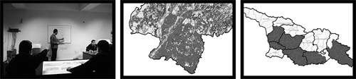
Full Activity Title: Integration of LMDP and KFW Cadastral Data Location: Regions of Kakheti, Kvemo Kartli, Shida Kartli, Imereti, Samegrelo Activity Dates: June, 2004 – November, 2005 Source of Funding: KfW Land Cadastre and Register Project
Project Abstract The goal of the project is to integrate Land Market Development Project and KfW project data for 21 rayons of Georgia and create unified database of cadastral information; accommodate data in the database, software and numbering system; identify and correct parcel overlaps and gaps. Project activities cover several steps. Cadastral information prepared by two projects is digitalized at Sakrebulo level and relevant orthopotos are printed; private and state-owned land parcels are checked on sites. The team of the project obtains cadastral information on the territories not surveyed earlier, examines digital cadastral information, prepares digital cadastral information for the entire territories of rayons and delivers integrated data to KfW project to be handed to the National Agency of Public Registry. Integrated database enables digital registration of rights to real estate; in addition it supports local authorities in an effective land administration and management. |
|||
|
APLR Head Office in Tbilisi Copyright © 2006, Association of Professionals on Land and Realty |
||||